Video is optimized for broadband access.
Wide-angle lenses used to record video straighten the curves
out. For a truer sense of twistiness watch the mirror dip .
At a Glance
The small town of Mariposa is named for the
beautiful wildflowers that surround it. And one of the prettiest
is the perennial favorite that unfolds its petals up to Yosemite
National Park. Opening up from Mariposa through the oak
woodlands in a series of sweeping arcs, the “Yosemite All Year
Highway” clears the Midpines Summit, then intertwines with Bear
Creek, climbing up its steep canyon wall before dropping
sharply, crossing the creek and bedding down beside the wild
Merced River. The most consistently scenic route of the three
DHs into the park is also the least trafficked, though at peak
times, it can be bad here too. Still its dotted-yellow
straightaways and pullouts in the curvier sections usually
provide enough Pylon-Killer™ to weed out the thorny vehicles.
Pavement and Engineering are generally well cultivated although
some of the off-camber and decreasing-radius turns along the
Merced between the Briceburg Info Center and the Indian Flat Day
Use Area could use some rototilling. The best part of this TIRES
arrangement is arguably the last segment, beyond Arch Rock and
the park toll booth. Even though the road narrows here and the
speed limit drops, you can catch glimpses of Yosemite’s sights
while twisting through the spectacular, granite-filled Merced
Canyon. Is this what they mean by flower power?


 No. of Ratings:
 Back
Back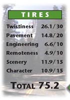 At a Glance